Θέλετε να αντιδράσετε στο μήνυμα; Φτιάξτε έναν λογαριασμό και συνδεθείτε για να συνεχίσετε.
eSSENTIALs aNGLo hELLENIc eNCYCLOPAEDIa
Φόρουμ
Πόρταλ
Εικονοθήκη
Latest images
Αναζήτηση
Ερώτημα αναζήτησης
Αποτελέσματα Αναζήτησης
Δημοσιεύσεις
Θεματικές Ενότητες
Σύνθετη Αναζήτηση
Εγγραφή
Σύνδεση
::
eSSENTIALs aNGLo hELLENIc eNCYCLOPAEDIa
::
Ελλάς : Hellas
::
Atlantes
Ό χάρτης του Πιρι Ρεϊς (1513) : Piri Reis map
Συγγραφέας
Μήνυμα
Admin
Admin
Αριθμός μηνυμάτων
:
8056
Registration date :
10/07/2008
Θέμα: Ό χάρτης του Πιρι Ρεϊς (1513) : Piri Reis map
28.10.08 18:45
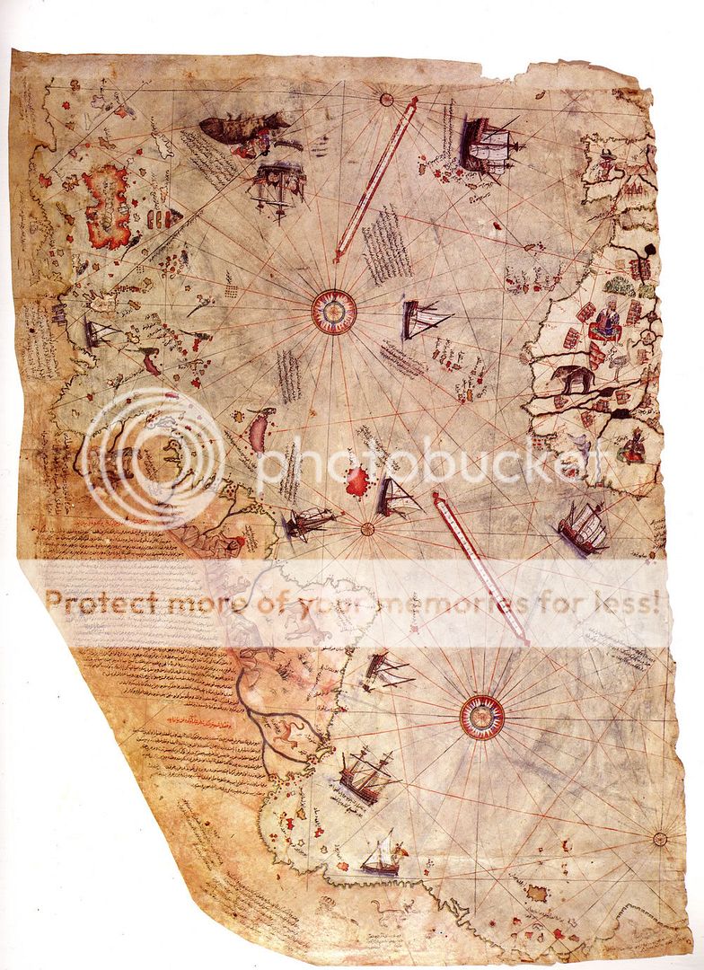
The Piri Reis map ("Piri" pronounced /piɹi/) is a famous pre-modern world map
created by 16th century Ottoman-Turkish admiral and cartographer Piri Reis.
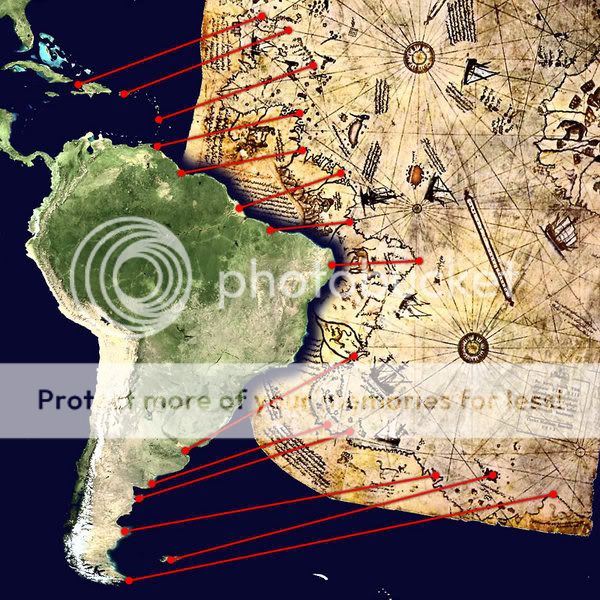
The map shows part of the western coasts of Europe and North Africa with reasonable accuracy,
and the coast of Brazil is also easily recognizable. Various Atlantic islands including the Azores and Canary Islands are depicted,
as is the mythical island of Antillia.
The map is noteworthy for its depiction of a southern landmass that some controversially claim
is evidence for early awareness of the existence of Antarctica.
The map was discovered in 1929 while Topkapı Palace was being converted into a museum.
It is the extant western third of a world map drawn on gazelle skin.
The surviving portion primarily details the western coast of Africa and the eastern coast of South America.
The map was drawn in 1513 by Piri Reis, a famous admiral of the Turkish fleet, and presented to the Sultan in 1517.
Piri Reis stated that the map was based on about twenty charts and mappae mundi.
According to Piri these maps included eight Ptolemaic maps, an Arabic map of India,
four newly drawn Portuguese maps of their recent discoveries, and a map by Christopher Columbus of the western lands.
The map in a higher resolution
Μου αρέσει
Δεν μου αρέσει
Ό χάρτης του Πιρι Ρεϊς (1513) : Piri Reis map
Σελίδα
1
από
1
Παρόμοια θέματα
Παρόμοια θέματα
Δικαιώματα σας στην κατηγορία αυτή
Δεν μπορείτε
να απαντήσετε στα Θέματα αυτής της Δ.Συζήτησης
::
eSSENTIALs aNGLo hELLENIc eNCYCLOPAEDIa
::
Ελλάς : Hellas
::
Atlantes
::
eSSENTIALs aNGLo hELLENIc eNCYCLOPAEDIa
::
Ελλάς : Hellas
::
Atlantes
Μετάβαση σε:
Επιλέξτε μια Δημόσια Συζήτηση
|
|--eSSENTIALs aNGLo hELLENIc eNCYCLOPAEDIa
|--.::See first::.
|--What's New
| |--Image of the Day
| |--Most Interesting
|
|--Music
| |--Learning & Training
| |--Guitars
| |--Pianos & Synthesizers
| |--Drums
| |--Music Creating
| |--Various
| |--Music
| |--Scores
| |--Music
| |--Music
| |--Radios on line
| |--Apsou Radio
|
|--Arts
| |--Poetry
| |--Fine
| |--Esoteric
| |--Literature
| |--Science fiction
| |--Photography
| |--Fantasy
| |--Martial
| |--Erotic
| |--Comics
|
|--Science
| |--Philosophy
| |--Dictionaries
| |--Space, Astronomy & Astrophysics
| |--Architecture
| |--Must See
| |--Psychology, Μedicine & Biology
| |--Astrology
| |--Unclassified
|
|--Ελλάς : Hellas
| |--Atlantes
|
|--P.C.
| |--Essentials
| |--Multimedia
| |--Graphics & Image
| |--Internet
| |--Useful Links : Χρήσιμες Ιστοσελίδες
| |--Games
|
|--Ideas
| |--Politics
| |--Aspects & Notions
| |--Economy
| |--Cartoons & Funny Pictures
| |--Τα πρωτοσέλιδα των ελληνικών εφημερίδων
|
|--Various & Happy Hour
| |--Funny Stuff
| |--Requests
| |--Whatever
| |--Garden
|
|--Anime
|--Fantasy Illustrations
|--Current Moon : Η Σελήνη σήμερα
|--Position of Earth and Moon today
|--Our Visits & Visitors
|--Virtual piano to play with your mouse or keyboard
|--Disabled
|--Broken links
|--Planet Earth
|--TV
|--Radio